
You might think scientists have already mapped every inch and understood every mechanism of our home planet, but recent technological leaps prove otherwise. Researchers continuously uncover stunning earth facts that rewrite standard textbooks and reshape your understanding of the world. Groundbreaking satellite imaging, deep-sea submersibles, and advanced seismic monitoring systems recently revealed hidden continents, massive underground oceans, and shifting magnetic poles. These fresh science discoveries demonstrate that our planet remains a dynamic, evolving system full of surprising science rather than a static rock. By staying updated on these educational facts, you gain practical insights into the natural forces directly impacting global climate, weather patterns, and future technological adaptations.
Fast Facts
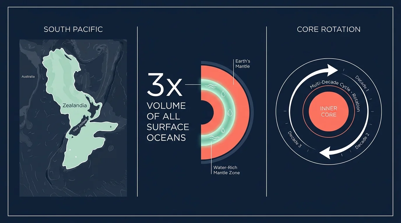
Geologists recently confirmed that Earth hides an entirely submerged eighth continent called Zealandia beneath the deep waters of the Pacific Ocean. Scientists mapped this massive landmass—which broke away from the supercontinent Gondwana tens of millions of years ago—using advanced satellite bathymetry and ocean-floor rock sampling. This geological marvel fundamentally alters traditional models of continental crust formation and tectonic drift.
Deep beneath your feet, a massive reservoir of water remains permanently trapped within the Earth’s mantle inside a vibrant blue mineral called ringwoodite. Mineralogists discovered that this subterranean zone holds approximately three times the volume of all surface oceans combined. This incredible deep-earth water source constantly regulates the global hydrologic cycle and influences explosive volcanic activity worldwide.
The solid inner core of our planet recently surprised geophysicists by slowing its rotation and potentially reversing its spin direction relative to the surrounding mantle. By analyzing complex seismic waves generated by thousands of recurring earthquakes, researchers mapped out a fascinating multi-decade cycle of core oscillation. These profound shifts deep underground directly influence the precise length of your day and the overall stability of the global magnetic field.
You rely heavily on the Earth’s magnetic field to protect your complex electronics and guide your smartphone’s GPS, but scientists recently tracked the magnetic North Pole sprinting rapidly toward Russia. This accelerated, unpredictable movement forces international cartographers and aviation agencies to frequently update the crucial World Magnetic Model. The shifting magnetic shield highlights the chaotic, powerful fluid dynamics continuously churning within the Earth’s outer liquid iron core.
Atmospheric scientists observing data from solar observatories recently confirmed that Earth’s atmosphere stretches significantly further into deep space than previously taught in standard science classes. Advanced sensor readings show that the geocorona—a massive, glowing cloud of hydrogen atoms—extends well past the physical orbit of the Moon. This incredible discovery means that human astronauts traveling to lunar orbit never actually leave the outermost protective fringes of Earth’s atmosphere.
Sophisticated seismic sensors placed along deep ocean trenches reveal that shifting tectonic plates drag billions of tons of seawater deep into the Earth’s interior. Geologists recently confirmed that these massive subduction zones transport significantly more water down into the mantle than historical predictive models estimated. Understanding this massive planetary hydration cycle helps structural engineers and urban planners better predict the frequency of catastrophic, deep-focus earthquakes.
The incredibly rich, vibrant ecosystem of the Amazon rainforest relies almost entirely on ancient dust storms originating thousands of miles away in the Sahara Desert. Climatologists tracked millions of tons of nutrient-rich phosphorus blowing across the Atlantic Ocean every single year to fertilize the dense South American vegetation. This intricate intercontinental connection provides concrete proof that localized ecosystems depend heavily on delicate global atmospheric transport networks.
Biologists exploring extreme, hostile environments recently confirmed that vast networks of subglacial lakes buried under Antarctica host thriving, ancient microbial communities. By drilling carefully through miles of solid ice, researchers retrieved pristine water samples containing resilient bacteria isolated from the surface world for millions of years. These incredible extremophiles provide you with a crucial biological template for understanding how extraterrestrial life might survive on icy moons like Europa or Enceladus.
Our planet continuously emits a mysterious, low-frequency hum radiating through the crust; seismologists recognize this fascinating planet fact as persistent microseismic activity. Researchers confirmed that this constant background noise stems from massive ocean waves relentlessly striking the continental shelves around the globe. By actively tracking this acoustic energy, scientists can accurately monitor severe ocean storm intensity and map hidden underground geological structures without waiting for unpredictable earthquakes.
Recent global environmental studies conclusively demonstrate that human-made microplastics now severely contaminate the absolute most remote, pristine environments on our planet. Researchers found microscopic synthetic clothing fibers resting heavily at the crushing bottom of the Mariana Trench and embedded deeply within fresh snowfall at the summit of Mount Everest. This alarming distribution confirms how powerful ocean currents and atmospheric winds indiscriminately circulate persistent modern pollutants across every global latitude.
Climatologists recently observed a dramatic, concerning increase in the frequency of global lightning strikes linked directly to steadily rising atmospheric temperatures. Warmer surface air holds significantly more moisture and generates much stronger convective updrafts, creating the perfect thermodynamic conditions for massive, energetic thunderstorms. Monitoring these intense electrical storms provides you with a crucial, real-time climate indicator and helps urban planners design vastly improved infrastructure surge protection.
Geophysicists mapping the deep interior recently identified colossal, mysterious rock structures sitting quietly within the lower mantle beneath Africa and the Pacific Ocean. Known technically as Large Low-Shear-Velocity Provinces, these massive thermal anomalies sit near the core-mantle boundary and act like giant planetary heat pumps. Scientists firmly believe these ancient, dense structures shape everything from magnetic field generation deep inside the planet to the precise location of massive volcanic eruptions on the surface.

Context and Background
For decades, researchers relied on localized field studies and rudimentary surface measurements to build basic models of planetary behavior. Today, high-resolution satellite constellations and automated deep-sea autonomous vehicles capture petabytes of raw environmental data every single day. Global scientific agencies like NOAA process this massive information influx using advanced machine learning algorithms. By analyzing complex patterns in ocean temperatures, atmospheric pressure changes, and tectonic stress indicators, modern geologists uncover profound educational facts that completely shatter outdated scientific dogmas. You benefit directly from these technological leaps because precise environmental monitoring leads to vastly improved severe weather forecasting and comprehensive disaster preparedness.
Scientists map the inaccessible depths of the Earth using a fascinating technique called seismic tomography, which functions similarly to a medical CT scan for the entire planet. When massive earthquakes shatter the crust, they send powerful acoustic energy waves traveling directly through the inner layers of the Earth. Global monitoring networks meticulously record the exact speed and trajectory of these deep seismic waves. Because acoustic waves travel much faster through dense, cold rock and significantly slower through hot, molten magma, researchers can reconstruct incredibly detailed, three-dimensional maps of the deep mantle and outer core. This precise acoustic imaging directly enabled the recent discovery of massive subterranean water reservoirs and ancient, continent-sized rock formations lingering near the core-mantle boundary.
Measuring the precise shape, mass, and magnetic field of the Earth requires incredible vantage points positioned high above the atmosphere. Space organizations like ESA operate specialized satellite constellations designed specifically to monitor invisible planetary forces continuously. These highly sensitive orbital instruments detect microscopic fluctuations in gravitational pull, revealing hidden tectonic structures like Zealandia resting silently beneath the ocean waves. Furthermore, sophisticated magnetometers mounted on these low-earth orbit satellites track the exact movement of the planet’s shifting magnetic poles. You utilize this highly accurate orbital data every single time you open a navigation application on your smartphone or track a commercial flight charting a course across the globe.
Exploring the deepest, most hostile environments on Earth presents immense engineering challenges that researchers only recently managed to overcome. Biologists hunting for extremophile organisms deploy specialized hot-water drilling rigs to penetrate miles of solid Antarctic ice without severely contaminating the isolated subglacial lakes hidden below. Similarly, marine geologists utilize heavily reinforced, uncrewed submersibles designed to withstand the crushing physical pressure found at the very bottom of the Mariana Trench. These impressive mechanical innovations allow scientists to safely retrieve pristine physical samples from previously unreachable domains. By pushing the boundaries of extreme engineering, scientists deliver practical insights into biological resilience and continuously expand your understanding of exactly where cellular life can successfully thrive.

Interesting Connections
Uncovering these fresh science discoveries demonstrates exactly how seemingly isolated natural systems remain deeply interconnected across massive global distances. You might assume that a desolate, arid environment like the Sahara Desert shares absolutely nothing in common with the lush, vibrant canopy of the Amazon rainforest. However, the exact opposite holds true; the massive South American jungle fundamentally depends on the regular atmospheric delivery of nutrient-dense African dust. This intricate planetary relationship highlights a critical ecological reality: localized conservation efforts must always account for broad, global atmospheric patterns. Understanding this immense dust transport network helps agricultural experts better predict regional soil fertility and intelligently manage global food production systems.
The surprising science found deep within the Earth’s mantle directly influences the delicate atmospheric conditions you experience on the surface every single day. The massive volume of water dragged aggressively down into subduction zones and subsequently stored within deep-earth minerals does not remain permanently trapped underground forever. Volcanoes continuously recycle this crucial water vapor back into the atmosphere through violent surface eruptions and slow, steady hydrothermal venting. This relentless, millions-of-years-long planetary hydration cycle acts as a vital global thermostat, effectively moderating surface temperatures and maintaining a stable climate. When you grasp the sheer physical scale of deep-earth water recycling, you gain a much deeper appreciation for the complex geological forces required to keep our planet consistently habitable.
Exploring the extreme, hostile boundaries of our own planet actively accelerates the ongoing search for extraterrestrial life across the broader solar system. When astrobiologists closely study ancient, resilient bacteria thriving in the pitch-black, freezing subglacial lakes of Antarctica, they gather vital operational data intended for future space missions. Organizations like NASA directly apply the practical engineering lessons learned during complex deep-ice drilling on Earth to the robotic probes designed to explore the frozen oceans of Jupiter’s moon Europa. These fascinating earthly extremophiles conclusively prove that biological life requires only a basic energy source and liquid water to flourish, fundamentally expanding your perspective on humanity’s ultimate place in the universe.
The erratic, unpredictable behavior of the Earth’s inner core and shifting magnetic field directly impacts the modern technological infrastructure that powers your daily routine. The crucial magnetic shield deflecting harmful solar radiation constantly twists, weakens, and shifts in direct response to complex fluid dynamics churning deep inside the liquid outer core. As the magnetic North Pole rapidly sprints across the Arctic Ocean, international regulatory agencies must constantly rewrite the crucial navigational algorithms used by commercial shipping fleets, military aircraft, and ordinary smartphone applications. Recognizing the direct, unbroken link between deep-earth geophysics and modern digital navigation gives you practical insight into exactly why vital software updates frequently recalibrate your everyday digital tools.
Frequently Asked Questions
How do geologists map entirely submerged landmasses like the hidden continent of Zealandia?
Geologists rely primarily on highly advanced satellite altimetry and ocean-floor bathymetry to accurately map hidden underwater continents. Satellites orbiting the Earth utilize sensitive radar to measure tiny variations in the exact height of the ocean surface. Massive underwater mountains and dense continental crust exert a stronger gravitational pull than the surrounding oceanic crust, causing seawater to visibly bulge upward. By measuring these microscopic surface anomalies, oceanographers generate precise topographical maps of submerged landmasses without draining the water. Researchers then physically deploy ships to collect core rock samples, conclusively proving the specific continental origin of the crust.
Why does the magnetic North Pole move so quickly, and will it cause a disastrous magnetic reversal?
The magnetic North Pole moves rapidly because the Earth’s magnetic field generates from swirling currents of superheated liquid iron churning within the outer core. These massive subterranean fluid movements shift unpredictably due to internal heat gradients and planetary rotation. While the recent acceleration toward Russia forces frequent software updates for your GPS devices, geophysicists confirm that this rapid movement does not immediately signal an impending magnetic pole reversal. Paleomagnetic data extracted from ancient rocks clearly shows that while the magnetic poles frequently flip over massive geological timescales, the complex process typically takes thousands of years to complete safely.
What exactly constitutes a subterranean ocean, and how does it differ from a regular surface sea?
When scientists discuss a subterranean ocean hidden within the mantle, they do not mean a sloshing cavern filled with liquid water. Instead, the incredible pressure and heat found hundreds of miles underground force water molecules to permanently bind directly into the microscopic crystal structure of rocks. A unique mineral known as ringwoodite acts like a rigid geological sponge, trapping immense quantities of hydrogen and oxygen ions within its dense lattice. This solid-state reservoir holds far more total water than every surface ocean combined, fundamentally driving global tectonic plate movement and deep volcanic activity.
How do recent discoveries regarding Earth’s extended atmosphere impact modern space travel?
The stunning revelation that Earth’s geocorona stretches past the Moon forces aerospace engineers to rethink orbital mechanics and spacecraft design. While the glowing cloud of hydrogen atoms remains incredibly thin, it still exerts a microscopic, persistent drag on satellites and lunar space stations. Navigational computers must actively account for this subtle atmospheric friction to prevent expensive orbital assets from degrading their trajectories over time. Additionally, ultraviolet sensors on deep-space telescopes must carefully filter out the persistent light interference generated by this extended atmospheric halo to capture clear images of distant galaxies.
Can monitoring the Earth’s continuous microseismic hum actually help scientists predict severe weather?
Yes, scientists directly utilize the persistent, low-frequency hum radiating through the crust to precisely track massive oceanic storms and powerful hurricanes. Because this constant microseismic background noise originates from ocean waves forcefully striking shallow continental shelves, the intensity of the seismic hum perfectly matches the raw physical power of offshore weather systems. By actively analyzing these subtle ground vibrations using sensitive seismometer networks, meteorologists can accurately measure the destructive force and trajectory of distant storms. This unique tracking method provides you with far more accurate severe weather warnings, crucially supplementing traditional satellite imaging during thick cloud cover.